May 4, 2017 – A Storm that Will Live in Infamy
On May 4, 2017 a powerful series of storms hit Thurston County with 60-80 mile per hour winds, 600 lightening strikes and record-breaking rainfall. It was epic. Some people are wondering, what happend exactly?
Was it a severe thunderstorm? A tornado? A microburst? Something else? The answer is yes to all, but the tornado.
The National Weather Service reviewed the evidence and determine it was not a tornado but rather a Derecho, also called a Straight Line Wind event.
Depending on where you live, you likely experienced all or some of these nasty effects.
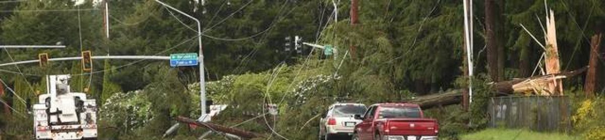
Lacey Hit Hard by Winds Strong Enough to Uproot Huge Trees
The first and most powerful storm approached the area southeast of Olympia and tracked toward Dupont. An area about ten miles wide experienced what were likely 60 to 80 mile per hour winds and truly record breaking rainfall. The storm produced over 600 lightning strikes from Chehalis through DuPont. Some people reported hail the size of half dollars just south of Lacey.
The damage in Lacey was so severe that if you could have easily concluded that a tornado did touch down because of the demolished homes and massive trees that were uprooted.


Here’s What Caused Wind Powerful Enough to Snap Trees

This is a downdraft produced by major thunderstorms that causes air currents to rush outward below a thunderstorm. Most of the damage patterns suggest that this is the case. Snapped off trees and power poles indicate that this downdraft was a potent blast and very rare for our area.
The amount of lightning was incredible. There were multiple reports of ground strikes all over the area. The rainfall was also extraordinary. The highest rainfall rates were calculated by King 5 Doppler radar at 14.36 in/hr.! Luckily the intense rain only lasted 10 minutes or we would have had very serious flooding issues and possibly some very dangerous
The storm covered a large area but its effects were very different in Olympia than they were further east toward Lacey and southeast of Lacey. The city of Olympia saw an incredible lightning show and received very heavy rainfall but did not experience winds.
The Scientific Explanation
An unusual weather anomaly came together. The combination included a tropical flow of air from the south, combined with a high resident humidity, surface temperatures in the upper 70s and the key, and ideal wind shear in the upper atmosphere caused by the jet stream.
These factors led to an unusually high convective index, or potential energy available to move moisture and energy from the surface to the upper reaches of a cloud.
The towering thunderstorms reached well into the Stratosphere, over 40,000 feet above the ground. That is a very rare event for Western Washington where most thunderstorms are truncated by westerly shear winds before they can explode above 30,000 feet.
That was the setting for what came next: One of the most severe thunderstorm events in most peoples’ memory.
Officially what happened was called a “Microburst” or “Straight Line Winds” or “Derechos”. These are very strong downward plumes of air that descend from high up in the thunderstorm. They are generally cold so they accelerate until the hit the ground then they spread out in arcs in a straight line below the cloud – hence the name. These can pack a punch as dangerous as a tornado. This is why many people thought tornados touched down. There is some anecdotal evidence that there were possibly some funnel clouds that may have briefly touched down but it was not substantiated by the National Weather Service who conducted an investigation.
The winds and other effects created by these storms are distinct in their pathway across the land. They have several characteristics that identify them as Straight Line winds:
- They have a distinct pattern of damage that indicates wind was directional (as opposed to a tornado which has a swirl pattern with debris being scattered in every direction equally.
- The direction of downed trees and powerlines indicate a series of focused blasts of wind blowing from the southwest to the northeast. This is very consistent throughout the damage areas along the path of the storm.
- Indication of violent directional shear winds. Evidence for this is the snapping of trees and power poles many feet off the ground as if there was a hand grabbing a tree and forcing it down and to the side strong enough to snap the trunk. This was clearly evident throughout the path of destruction between Tumwater and Nisqually.
- In Lacey along Yelm Highway several old growth trees mainline transmission poles were snapped and
- Radar Data indicating directional winds moving at high speeds or plumes dropping quickly from the storm clouds. These Storms can and did generate directional winds approaching one hundred miles per hour. There is also a clear direction of the storm’s movement. The May 4 storm encompassed an areas about 10 miles wide and about 20 miles long (around 200 sq miles!), from south of Tumwater to Tenino and travelled Northeast through parts of Lacey and Nisqually.
The winds come from a conveyor belt-type convection mechanism. Warm and moist air accelerates up the front or back side of the thunderstorm high up into the storm’s core and emerges in the upper atmosphere where it cools very rapidly and begins to fall back to the surface. Its moisture freezes into ice and rubs against surrounding particles creating a huge static electric field which results in the fierce lightning generated by this storm. It’ like the lightning balls (Van de Graaff generators) you may have seen in school that create a static charge when the elastic belt is running. They discharge the electricity from the metal ball at the top in an arc several inches or up to a foot long. I used to love those things in science class.
