May 4, 2017 A Storm System that Will Live in Infamy

Updated September 27,2017

Tornado and Rainbow

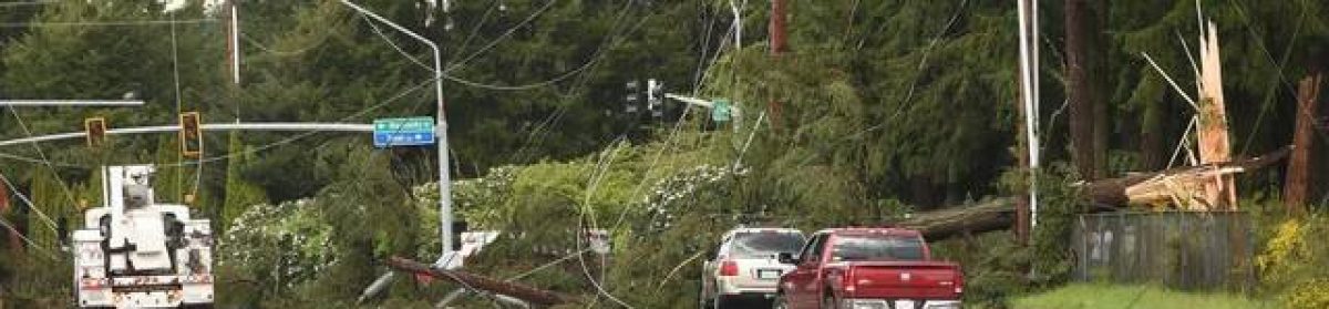
So what was that storm that hit us on May 4th, 2017 ?”  Was it a record-breaking severe thunderstorm, a tornado, a microburst or something else? The answer to that question is yes to all but the tornado part.  Depending on where you live, you experienced all or some of these nasty effects from a series of storms that dozed over us on May 4th.  The first and most powerful storm approached the area southeast of Olympia and tracked toward Dupont.  An area about ten miles wide experienced what were likely 60 to 80 mile per hour winds and truly record breaking rainfall.  The storm produced over 600 lightning strikes from Chehalis through DuPont.  Some people reported hail the size of half dollars just south of Lacey.

Continue reading “May 4, 2017 A Storm System that Will Live in Infamy”

The Big Spring Storm: Experts Confirm It was Not a Tornado

May 4, 2017 – A Storm that Will Live in Infamy

On May 4, 2017 a powerful series of storms hit Thurston County with 60-80 mile per hour winds, 600 lightening strikes and record-breaking rainfall. It was epic. Some people are wondering, what happend exactly?

Was it a severe thunderstorm? A tornado? A microburst? Something else? The answer is yes to all, but the tornado.

Continue reading “The Big Spring Storm: Experts Confirm It was Not a Tornado”

What Caused the Spring Wind Storm?

A view of Thurston County’s Spring 2017 Wind Storm from Space.

In April 2017, Thurston County was hit by what some believed was a tornado that cut a path of destruction North along Interestate 5 from Dupont through Rochester. It ripped 100 foot diameter trees up by their roots, splintered evergreens along its path.

Here’s what that large storm looked like from the GOES 15 satellite stationed above the Northern Hemisphere.  Here’s what caused it …

Continue reading “What Caused the Spring Wind Storm?”