by Mark Biever, L.G., L.E.G. Environmental Monitoring Program Supervisor for Thurston County
Summer Outlook
Here we are again already in the middle of Summer and things are heating up for the Northwest. Looking at the medium range forecast (30 – 60 days) for our area of the Puget Sound, we are shaping up to be on the dry side. It is becoming more common in the past ten years that our summers are getting hotter, drier and longer. This is what the climate models have predicted for our area and it seems to be following the script closely. The summer of 2018 is predicted to be warmer than average and very dry, in fact, we are predicted to be in the drought territory by the end of July. At this point it does not appear to be as severe as the 2015 drought, but it is well under way and we won’t know its extent until fall. Even the 4th of July was rain free.
What to expect the last week of January and first week of February
If we thought we would escape some harsher winter weather this year, unfortunately we will not be able to completely avoid it. According to the medium range forecasts released by the National Weather Service, in the last half of January the west coast will be seeing some wild weather from California to Alaska. It will likely include temperatures slightly below normal and some powerful storms bringing significant rainfall to our area.
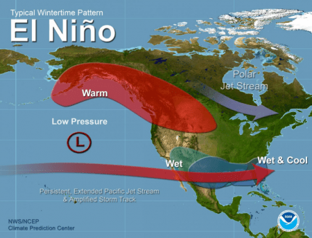
There is even the possibility of snow or freezing rain as some of the arctic air that has plagued Siberia (-90° F) and the Eastern United States take a glancing blow at the Western US. The west has been enjoying a fairly mild winter to date with temperatures above normal and precipitation near normal. This weather does not follow the La Niña pattern initially forecast and has actually been more typical of an El Niño winter.
There is still the problem with forecasting even the medium range outlooks because the past patterns are not able to accurately predict the current climate trends. Putting that aside for a moment, there is strong agreement between several models that we are in store for some nasty weather in the coming couple weeks so it’s best to be prepared in the event flooding occurs.
What to Expect & Where
For Thurston County, we may see some high groundwater and some stream or river flooding. We currently have above average groundwater, lake levels, and streamflows that have remained above average since the wet, prolonged winter of 2016-2017. Not significantly higher than average but higher nonetheless. A large storm or a series of storms could set the stage for flooding within the next couple weeks.
Here are in Thurston County:
The western third from Grays Harbor County line throughout the Black Hills and the Willapa Hills in the southwest part of the County. The Black River and Black Lake are often affected by flooding originating in the Black Hills and other western tributaries. The mid part of the Chehalis River also receives a significant portion of its flow from the weather systems that affect the Willapa Hills.
The next areas that are affected by large rainfall events are the central lowlands between the Black Hills and the Cascade foothills. This area includes the I-5 and Highway 99 corridors where the majority of the population of Thurston County resides. In this region, we have multiple flood prone creeks and streams that can flood if there is a period of high precipitation. These locations are also where our more susceptible lakes and groundwater flooding concerns arise. In particular, Lake St Clair and the Salmon Creek Basin high groundwater areas.
Lake St Clair is likely to see very high water levels if we experience the forecast 4-6 inches of rain within the next two weeks. Salmon Creek Basin is also quite likely to experience groundwater flooding in some of the more flood prone lower elevation.
The next area of concern is the Cascade foothills where the headwaters of the Nisqually River and the Deschutes River begin their journey to Puget Sound. This is also where the Chehalis River and its tributaries, such as the Skookumchuck River, get much of their water from as well.
Landslides are more likely. During high and prolonged rainfall events there is also a greater risk for landslides in many areas of the County. The most prone areas are where the slopes are greatest such as the Black Hills and the Cascade foothills but landslides can also occur in less obvious areas under the right conditions. In Thurston County we have such a variable geologic setting that susceptible soils are widespread throughout our area. But in general the Black Hills, the Cascade foothills including areas around Tenino and Bucoda and the Willapa Hills (Michigan Hill areas). These areas combine susceptible soils, steep slopes and high rainfall – all the ingredients to start the ground sliding.
Why Flooding is Likely in Thurston County
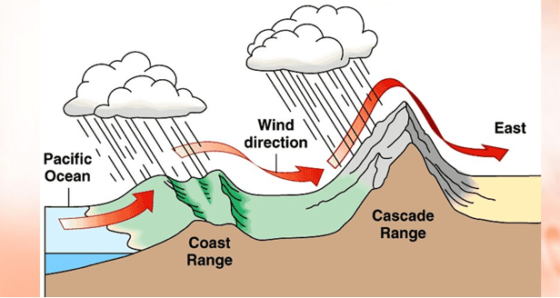
The areas and the possible problems listed above are a result of how our county is situated geographically in the Puget Sound Basin. We are located between the Olympics (Labeled ‘Coast Range’ below) and the Cascade Range, which causes the predominant weather patterns to get focused between these regions. Any gaps or higher elevation areas get more precipitation resulting in increased potential for flooding and the increased likelihood of landslides.
Another unique feature of Thurston County occurs in the Chehalis River valley known as the Chehalis Gap. This is a feature where the Chehalis River has eroded through the higher hills that make up the southern Black Hills and the Willapa Hills. This gap allows Pacific moisture to spill into the southern part of Thurston County without having to go over any higher elevation terrain. Because the storm can avoid going over high hills, it is not forced to drop its precipitation due to cooling.
Remember, as humid clouds have to rise over hills or mountains they bunch up and get cooler the higher up they have to climb to get over an obstacle such as the Black Hills. This increase in elevation cools the clouds and causes a lot of moisture to be dropped on the windward side of mountains. Think of Eastern Washington’s dramatically different climate compared to Western Washington. Eighty to 90 percent of the moisture from Pacific storms is lost over the westerns slopes of the Cascades and Olympics as the moist air is forced up over the mountains, leaving eastern Washington as dry as the Arizona desert!
This diagram illustrates how the mountain ranges affect moisture coming from the Pacific Ocean. As it encounters hills and mountains, it is forced to rise. As it rises, it cools dropping most of its moisture west of the Cascades and Olympics. Very little is rain is left as it crosses the Cascades into the dessert east of the mountains.
Another unique feature of Thurston County occurs in the Chehalis River valley known as the Chehalis Gap. This is a feature where the Chehalis River has eroded through the higher hills that make up the southern Black Hills and the Willapa Hills. This gap allows Pacific moisture to spill into the southern part of Thurston County without having to go over any higher elevation terrain. Because the storm can avoid going over high hills, it is not forced to drop its precipitation due to cooling.
Remember, as humid clouds have to rise over hills or mountains they bunch up and get cooler the higher up they have to climb to get over an obstacle such as the Black Hills. This increase in elevation cools the clouds and causes a lot of moisture to be dropped on the windward side of mountains. Think of Eastern Washington’s dramatically different climate compared to Western Washington. Eighty to 90 percent of the moisture from Pacific storms is lost over the westerns slopes of the Cascades and Olympics as the moist air is forced up over the mountains, leaving eastern Washington as dry as the Arizona desert!
This same effect occurs even with much smaller hills and mountains causing rain shadows (dry areas) and rain focusing (wet areas) around hills and valleys. The Chehalis Gap allows the Pacific moisture to sneak up the Interstate 5 corridor further without having to lose its moisture so it can penetrate further inland. This is why areas from Littlerock to Tenino and Grand Mound typically see 25 percent higher rainfall than further north in the I-5 corridor in the Olympia area.
Be Prepared: Twenty Inches More Rain than Normal is Possible
Because Thurston County is situated in such a unique nexus of topography, geology and Pacific air currents, we have the potential to go from a typical wet winter (average 52 in/yr.) to a flooding winter (> 70 in/yr.) very rapidly depending on the strength and location of storm systems approaching the west coast.
These conditions combined with high water levels from previous years can quickly lead to flood conditions. Looking at the short term two-week forecast, we may have the right conditions in place for some flooding to occur. As these conditions can occur rapidly it is always best to be prepared for floods especially if you live in the flood prone areas of Thurston County. Visit our website and sign up to receive flood alerts from Thurston County.
People who build in the 100-year flood plain or in high groundwater areas are especially vulnerable (see if your Thurston County property is in a flood hazard area). Most new homes and structures will be required under Thurston County Codes to be elevated at least two feet above the predicted 100-year flood elevation as determined for each flood area by the Federal Emergency Management Agency (FEMA). The reasoning behind elevating structures is to keep them above the determined high water flood elevation based on land surveys and flood plain models. The intent is to minimize or eliminate inundation of homes businesses, roads and utilities and protect lives and property. Even with the codes in place, it is still possible that flooding can occur in severe cases and the best protection if you live in a flood zone is to have flood insurance.
Flood Insurance Premiums are Lower in Thurston County
Thurston County has worked successfully to get flood insurance rates as low as possible through the Community Rating System (CRS) offered through FEMA.
The CRS recognizes and encourages community floodplain management activities that exceed the minimum NFIP standards. Depending upon the level of participation, flood insurance premium rates for policyholders can be reduced up to 45%. Besides the benefit of reduced insurance rates, CRS floodplain management activities enhance public safety, reduce damages to property and public infrastructure, avoid economic disruption and losses, reduce human suffering, and protect the environment. Learn more on the County’s website.
Technical assistance on designing and implementing some activities is available at no charge. Participating in the CRS provides an incentive to maintaining and improving a community’s floodplain management program over the years. Implementing some CRS activities can help projects qualify for certain other Federal assistance programs. If you live in a flood plain you can contact Thurston County’s Floodplain Manager, Tim Rubert, for details. Email Tim at rubert@co.thurston.wa.us or call him at 360-867-2123. You can also learn more online at FEMA’s website.
What is La Niña anyway? Why does it matter? and What does it mean for our winter weather?
Let’s answer these one at a time:
La Niña (literally the little girl in Spanish) is a sea surface temperatureanomaly in which the upper 300 feet (100 meters) of the tropical sea surface is cooler than average along the equator between South America and Indonesia. (See the graphic below) It is the opposite of El Niño which is characterized by warmer than average equatorial sea surface temperatures along the Pacific Equatorial region. The La Niña forecast for this winter is for a weak anomaly peaking in late winter.
The diagram above shows a below average “blue-colored plume” of equatorial water between South America and Indonesia. This is the unmistakable signature of La Niña. North America is to in the upper right of the diagram.
It matters to the Pacific Northwest because it causes changes in the tropical wind and moisture currents over much of the northern hemisphere. The changes in wind patterns cause a ripple effect that changes global wind patterns. The change usually allows cooler air to migrate southward from the arctic and nudges the jet stream over the Pacific Northwest where it translates into cooler, and generally wetter winters.
Having said that, there is of course a generalization made by many people equating bad winters with La Niña and warmer drier winters with La Niña’s brother, El Niño. The statistics do indicate there is a correlation but it is not a very good correlation. In fact, the winter of 2016-2017 was one of the coldest and wettest in 30 years for Western Washington. This occurred as a very strong El Niño was still in place over the Pacific equatorial zone. By all accounts the winter of 2016-2017 should have been very dry and warmer than average. It certainly was not.
There are many cases when this correlation is not evident because there are a lot other factors at play in the atmosphere that can have a more direct role in the winter weather in Western Washington.
There is enough data, however, to suggest that there is certainly an influence on winter weather generated by a La Niña. Even though the connection between these events is loose, there still is a statistical correlation between La Niña and a cooler, wetter winter.
What this meansis that we may see a cooler than average and wetter than average winter this year. But here’s the answer to the headline question “is this cold and snow we are seeing in the first week of November a result of La Nina”? La Niña and El Niño effects are not generally seen until mid to late winter and into early spring so the answer is probably not.
Don’t forget that only a couple of weeks ago we were in the mid to upper 60’s through most October and that was not caused by El Niño so there are more impactful patterns that effect the local weather and climate than just the tropical Pacific sea surface temperature anomalies. The old adage is somewhat true about the butterfly flapping its wings in the Pacific can cause a hurricane in the Atlantic. Not necessarily that dramatic but the input or withdrawal of energy in one part of the global weather system can have unpredictable (or difficult to calculate) outcomes throughout the whole climate pattern.
La Niña is not the bringer of a weekend of cold weather or an early snow but it could bring a cool trend later in the season. I’m still not going there. I think we will just about average for the winter.
Many people are wondering about the potential for an extended summer season that would continue our warm and dry weather into October and possibly longer. I will start out by saying it is certainly more likely this year than it was in 2016. You may recall that the day the calendar turned from summer to fall last year (September 21) we were done with summer and began one of the coolest winters in 30 years. It was also one of the wettest and most prolonged cool periods we have seen in the Pacific Northwest in a long time.
If you’re dreaming of a white Christmas – or at least of an opportunity to get out and play in the snow with your little ones – you’re going to get your wish. Weather models indicate this holiday season, will include some snow and plenty of cold weather.
That’s because an abundance of very, very cold air is crossing the Pacific from our Russian Comrades in far northwest Siberia. That is the coldest place in the Northern Hemisphere. Siberia’s average high temperature in December and January is minus 15 degrees Fahrenheit. That’s the high temp folks. The low temperatures can drop to minus 50 to minus 80 degrees below zero.
Get your mittens ready!
Expect extremely cold and dense air masses to flow from this artic region in early December. The air will be significantly warmed over the ocean before it beats us up, but it will still be below freezing and deliver our first shot of snow, even after travelling thousands of miles over the Pacific.
Once this pattern starts, it will likely persist for a while as the jet stream (that narrow band of strong wind that circles the globe several miles above land) tries to adjust to a huge high pressure ridge in its way. This could push the cold air mass as far south as the tropics, and wreak havoc with precipitation patterns. If the cold air dips that far south, it will pick up tropical moisture as it rebounds north. This tropical moisture will translate into very heavy snow and rain at the margins of the cold air mass. Models indicate that this margin, or intersection, will be right over Thurston County, and will keep us in a very active weather pattern as we experience the war between warm and cold air.
Will snow affect Santa’s Trek?
The good news is that Santa knows how to get through all kinds of bad weather. Although he will need the red glow of Rudolph’s now to guide him through the snow. For those who are young (or young at heart), you can track Santa’s journey online. There’s the Google Santa
Tracker https://santatracker.google.com/village.html and the NORAD Santa Tracker http://www.noradsanta.org/ The google countdown clock for Santa’s arrival has already started. Check it out! If however, you’ll be in the Southern Hemisphere for the holidays, Christmas is in the summer. Here’s my forecast for you: No snow. Now that is an easy prediction when it comes to holiday weather!
For everyone else, enjoy the cold and snow here in Thurston County, and keep warm!
Mark

 The diagram above shows a below average “blue-colored plume” of equatorial water between South America and Indonesia. This is the unmistakable signature of La Niña. North America is to in the upper right of the diagram.
